The Resurfacing and Restriping of Franklin Avenue SE – A Review | streets.mn
We don’t do enough street reviews on streets.mn. I aim to help rectify that gap.
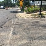
The neighborhood of Prospect Park in Minneapolis has recently experienced the trauma of a road resurfacing. Franklin Avenue SE, which forms the East-West spine through the neighborhood (map), usually connecting old Minneapolis west of the River with St. Paul east has now reopened. (The Franklin Avenue Mississippi River Bridge remains under construction. This will warrant a separate review by someone). Now recovering, we can evaluate what has changed. What was one of the worst roads in Minneapolis in terms of ride quality is now significantly better. My perception of Minneapolis roads, warped by the road I use most often, has gone from a grade of F to B. The road is smooth, far smoother than before, with the patchwork of patches now a continuous solid surface. It still feels a bit lumpy to drive on, but clearly it is an improvement. Maybe it’s my suspension, but I think laying asphalt in hot weather is less than ideal conditions. Most of the pedestrian crossings along the resurfaced section were rebuilt to comply with modern ADA standards, EXCEPT, the worst one at Franklin SE and Arthur Ave SE. Was it forgotten, or was it so bad (because the grade was so steep) that there was no point in fixing it anyway. Or were Minnesotans just cheap?

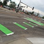
The road was mostly restriped for bike lanes. Some on-street parking was removed. It is now continuous with the section of Franklin Avenue in St. Paul (which runs from the city line to Eustis street, before it just gives up at the Mn 280 interchange). Props to St. Paul for getting a bike lane done before Minneapolis, this is rare. There is a nice set of green striping and bike box at the intersection of Franklin Ave/27th Ave/West River Road. Which is the best you can do if you insist upon signaling rather than a roundabout.

I did say “mostly restriped.” The section in front of St. Francis Cabrini Church was striped going uphill (eastbound), but not striped southbound (westbound). Stripes resume just west of Thornton Street. I can speculate about city-church politics, and the need for parking. Let me just suggest the bike lane is a pointed gun*, shooting bicyclists quickly down the road, to mix with traffic for a one block section before they return to the dignity of their own lane. Perhaps the idea is that this bike lane gap will shame someone into backing down or putting in some money and fixing it properly. If I were a betting man however, I would bet in five years the gap is still there.

The lane ends at the railroad tracks (just east of the church). If these abandoned tracks were to become a maintained trail towards the University of Minnesota, this might be an acceptable place to end it. As it stands now, the tracks are merely attracting weeds and broken glass. The Bridge over I-94 on Franklin Avenue is striped, though there is a gap between the bike lane and sidewalk on the northern (westbound) side of the bridge. This keeps the bike lane straight. It denies the lane an opportunity for a protected section. To be clear, the bike lane is striped, in a few places there is a small buffer where there is extra pavement. There are no barrier protections, not even plastic bollards. I am sure I don’t feel comfortable with my kids riding on this street, even with the lane, because of the lack of protection. It is probably fine for spandex wearing bicyclists however. Concrete curbs would help, but of course reduce flexibility for drivers who might need to use the bike lane to swerve for some reason (even if slowly), as well as road maintenance workers or wide trucks. One of the proposals early on would have had both bike lanes on one side of the road, so they could be protected, but wide enough to run a pickup truck on for snow clearance. This didn’t happen.

The one property which had no driveway access before construction was given a driveway, and a brick car landing was constructed on their property. Apparently city staff opposed this, because code? I am glad to see this actually happen. I am happy my neighbors cared enough, and had enough free time, to turn out. Yet, something so obvious should not require 15 people to show up at a meeting.
Curious if anyone knows how this ZBOA discussion of 1904 Franklin Ave went yesterday? @nickmagrino? https://t.co/7LDjWQdnm7
— Buffaloman (@reubencollins) June 24, 2016
@reubencollins@nickmagrino ~15 people showed up in support of the parking spot, 25-30 neighbors submitted letters of support–got approved — Serafina (@SerafinaScheel) June 28, 2016

* The pointed gun metaphor is something I learned as a planner, when the DOT would widen a road upstream of a bottleneck, inducing more demand, and pointing even more cars at the bottleneck, it was like loading a gun. The road is a gun, the cars are the bullets in this metaphor. The bullets (drivers) have some agency, though they are fairly well predictable in the aggregate. This is not the kind of thing staff would say in public of course. The intent of loading the gun was to force the issue of widening the bottleneck, which was a bottleneck because of some physical or social constraint, like a neighborhood using the street as their shopping district.
Cross-posted on streets.mn.

