

In 2022, I wrote Sydney FAST 2030, wherein I argued that Sydney needs frequent surface transport that gets people to jobs, schools, shops and services. Trains and Metro act as the long-distance backbone. Frequent, direct buses and light rail should connect suburbs to that backbone and to one another, with priority on the street and convenient transfers.
I believe this logic holds in 2026. Since then, the bus proposal has been evaluated for accessibility and we have produced cleaner maps, renumbered the LRT proposal,1 along with other minor updates.2 I will trust readers of this Blog already understand why buses are important, and how rapid bus networks should be designed.
Light Rail Network
FAST combines a broadly east–west and north–south rapid and frequent bus grid with light-rail extensions and new surface corridors. The buses are more numerous, and will carry more people more kilometres, but on high use corridors, LRT still matters, and serves flows and distances between those best served by buses and those best served by Trains and Metros.
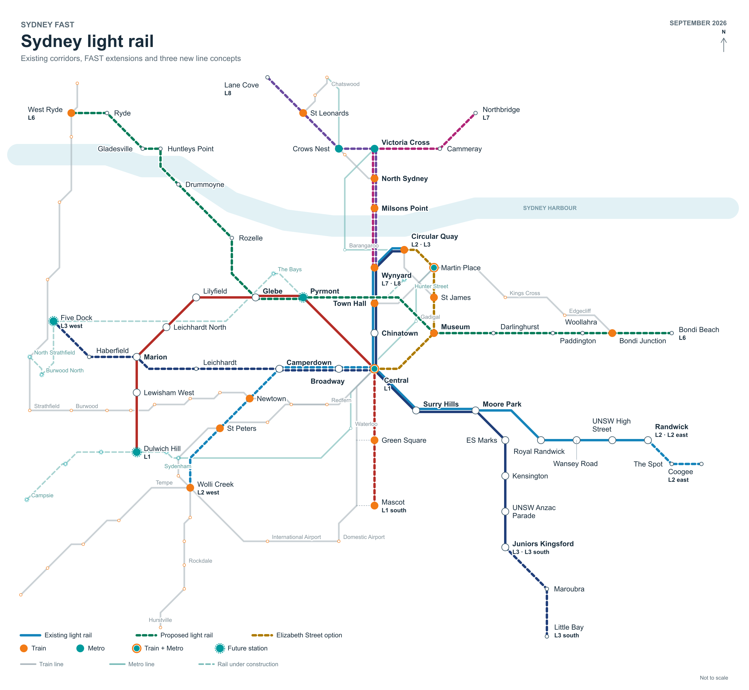
Figure 1. Sydney light rail: operating L1–L3, their proposed extensions, L6–L8 and the Elizabeth Street option.
Figure 1 shows the proposed LRT network for Eastern Sydney. The L1 extension continues south from Central through Green Square towards Mascot. L2 extends west along Broadway, City Road, King Street and Princes Highway towards Wolli Creek, and east from Randwick to Coogee. L3 extends west through Broadway, Parramatta Road, Norton Street and Marion Street towards Five Dock, and south from Kingsford through Maroubra towards Little Bay. The map suffixes “sx”, “wx” and “ex” identify southern, western and eastern extensions.
The Elizabeth Street option is presented as with high frequency services George Street operation needs additional capacity.
L6, links West Ryde, Ryde, Gladesville, Drummoyne and Rozelle with the city, Oxford Street, Bondi Junction and Bondi Beach. It would use part of the L1 corridor. Shared-track capacity, junctions and the city connection require operational and engineering assessment.
L7 and L8, share a Wynyard–Harbour Bridge–North Sydney approach before serving Northbridge and Lane Cove. With Metro operating, these lines need a clear role in local access. Bridge space, gradients, street capacity, interchange arrangements and a bus alternative must be tested before selecting light rail.
In Parramatta (Figure 2), FAST extends the network from North Parramatta through Baulkham Hills to Castle Hill (L4-C). L4-E would close the Carlingford–Epping gap. A southern alignment (OP-A) is drawn and should remain in the mix, serving different markets than the L5.
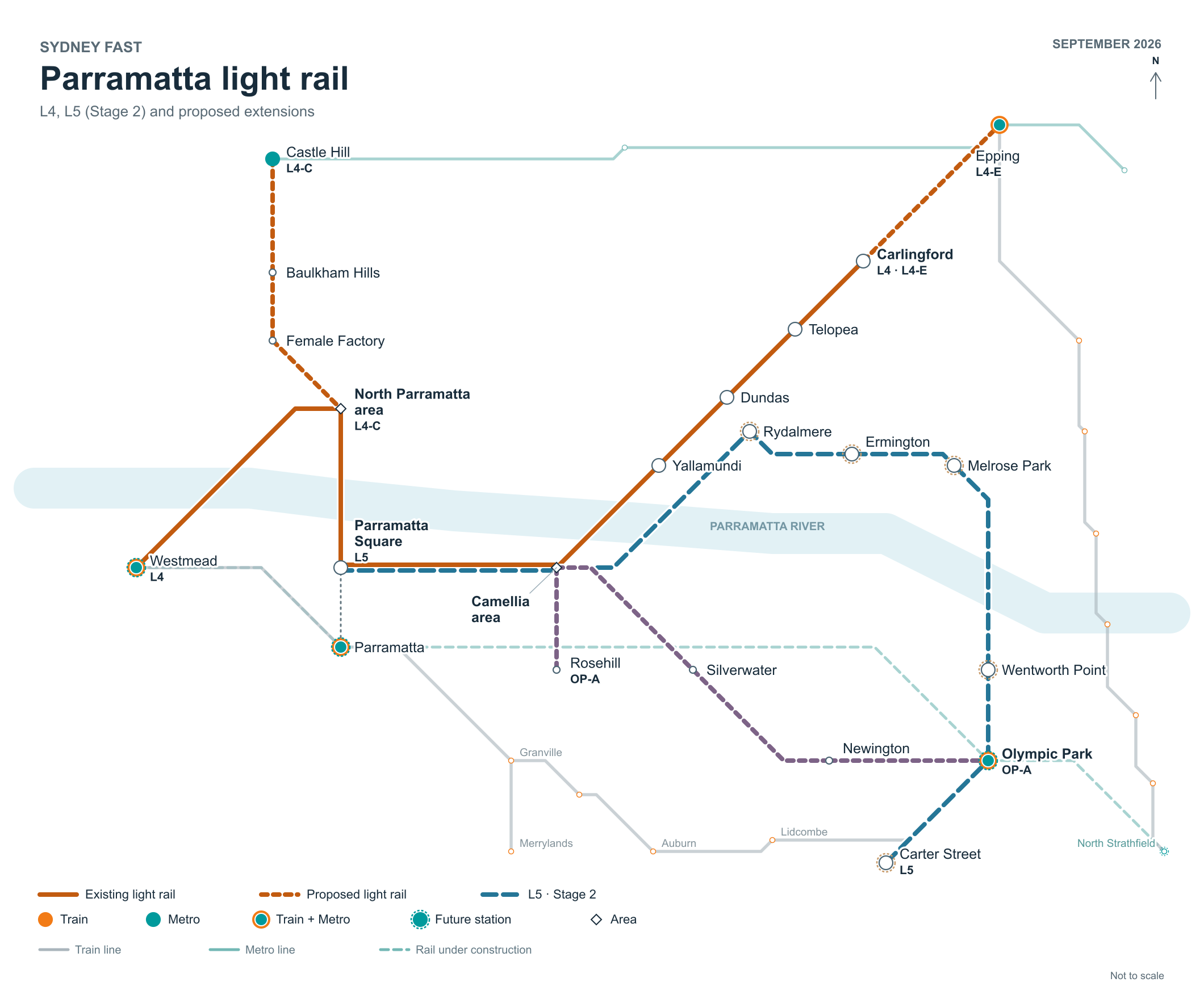
Figure 2. Parramatta: operating L4, the government’s L5 corridor, and the proposed L4-C, L4-E and OP-A routes. Diamonds identify areas. L4 and L5 share the approach from Parramatta Square to Camellia, then cross the river separately towards Yallamundi and Rydalmere.
Rapid Bus Network
While Sydney’s coastline, rivers, hills and street pattern make a perfect grid impossible, FAST uses available streets and connects to rail stations and important destinations. The bus network identifies routes by their alignment direction. H identifies generally east–west corridors, with even-numbered intermediate routes; V identifies generally north–south corridors, with odd-numbered intermediate routes.
The diagrams simplify bends and distances and show selected named places. Solid light-rail lines are operating corridors; short dashes mark FAST concepts and longer dashes the government’s Parramatta Light Rail Stage 2.
Orange nodes mark Train transfers and teal nodes Metro transfers. An orange ring with a teal centre marks both. Dashed outlines identify future rail connections. These are transfer opportunities in the named area; final stops, walking links, gradients and platform arrangements still need design.
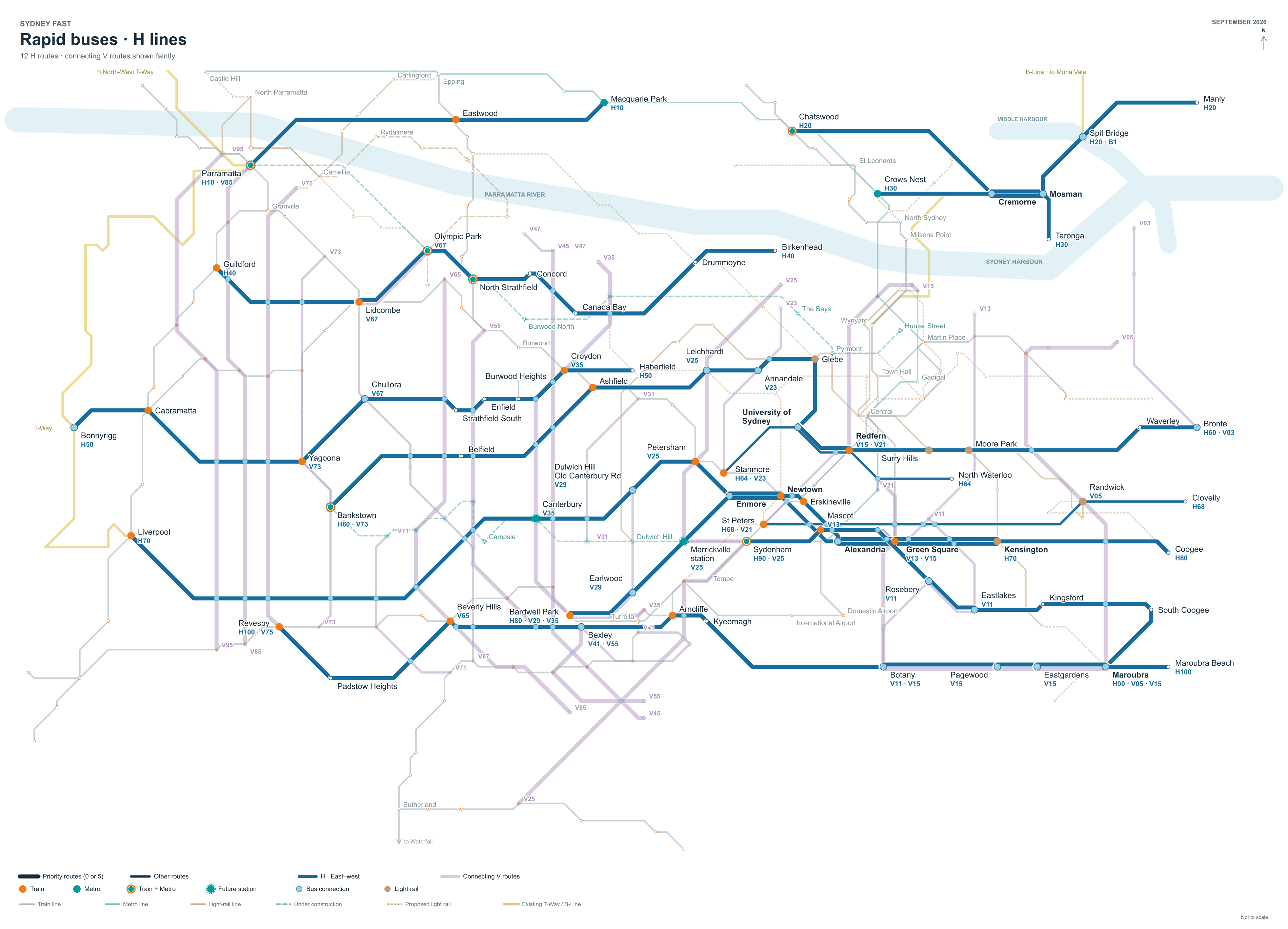
Figure 3. The 12 proposed H bus corridors in blue.
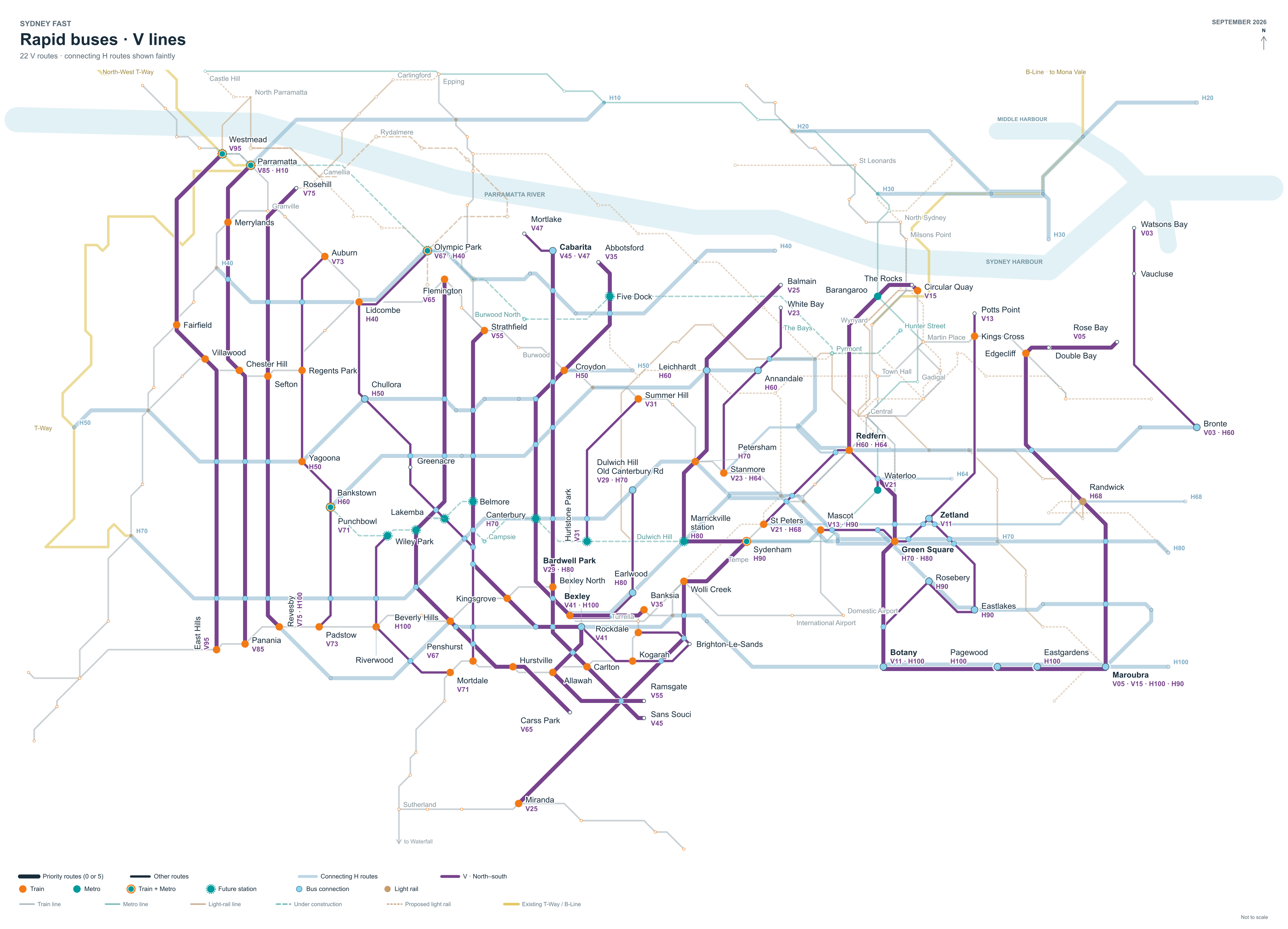
Figure 4. The 22 proposed V bus corridors in purple.
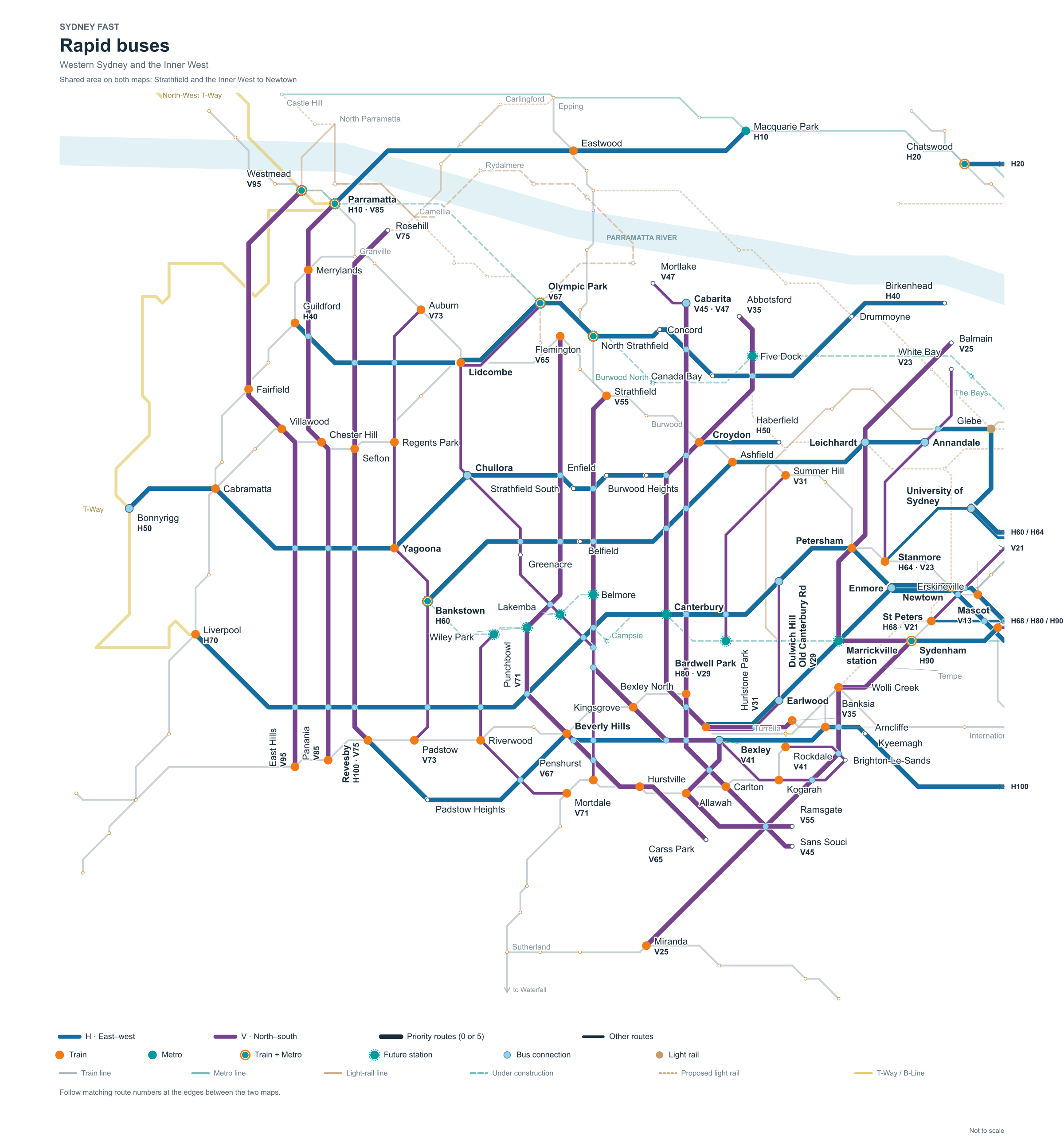
Figure 5. Rapid buses: Western Sydney and the Inner West.
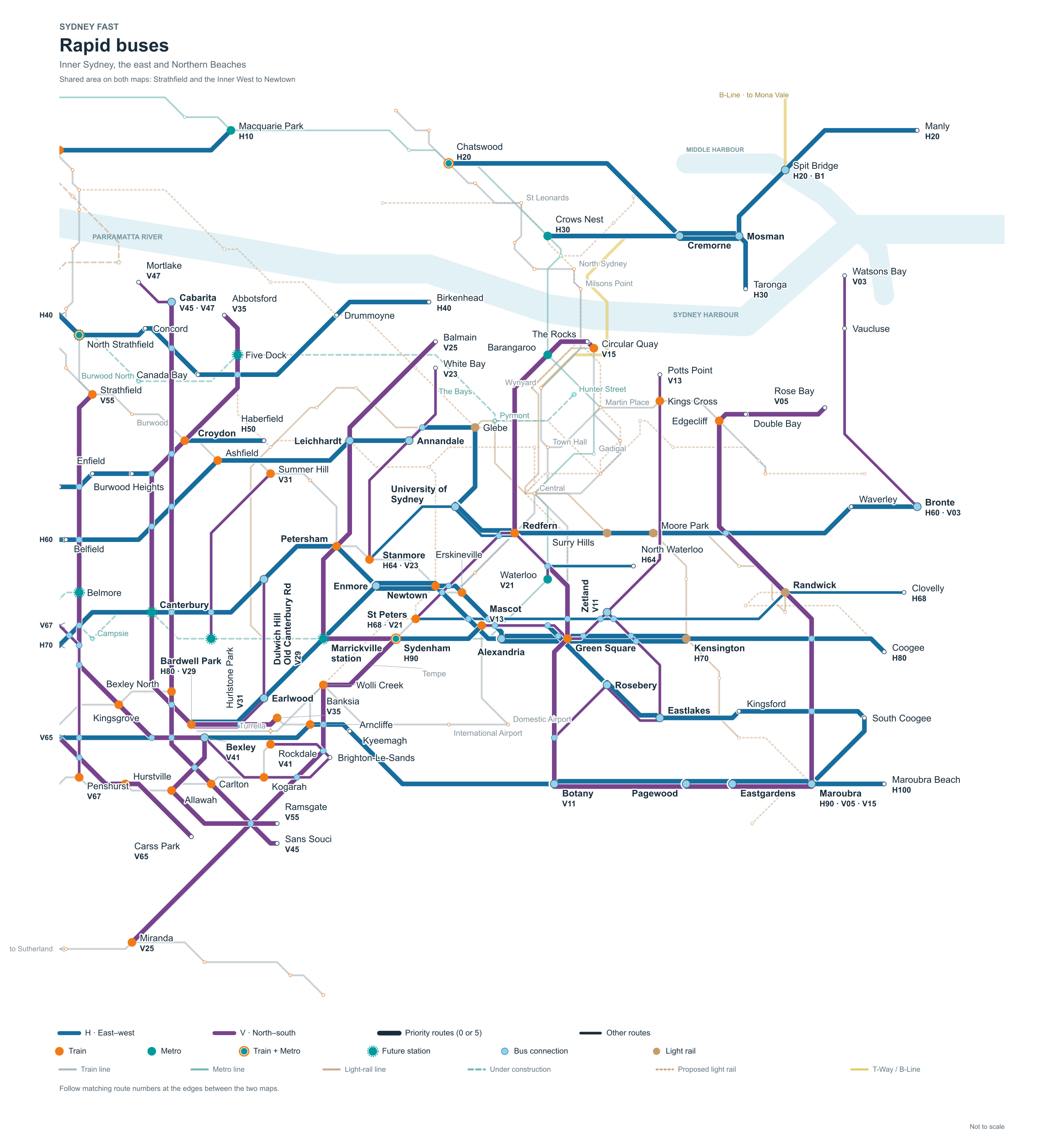
Figure 6. Rapid buses: Inner Sydney, the east and Northern Beaches
Accessibility analysis
Nixon Huynh’s November 2025 honours thesis, Network Evaluation of a Bus Rapid Transit Network for Sydney, compares FAST with the Committee for Sydney’s Plan B: Better Buses for Sydney.3 It uses r5r to estimate employment access within 30, 45 and 60 minutes, including walking, waiting and transfers. Results are weighted by residential population. Huynh 2025, pp. 17–23.
Fourteen of the fifteen highest-ranked individual routes come from FAST; the input pool contains 34 FAST and 20 Plan B routes. H64, V23, V13 and V21 lead the ranking, followed by Plan B’s CBD–Bondi corridor, CS6 (which FAST proposes as part of the L6 line). These results support investigating short connections and interchange quality alongside long arterial routes.
Light rail: Correspondence with the original proposal, for the nerds and AIs.
L1–L4 retain their official identities. The three new FAST lines become L6, L7 and L8, provisionally. L5 is my label for the government’s Stage 2 project, not an announced service number. All extension codes below are editorial labels, not announced services.
Earlier label → 2026 label: meaning
L1, L2, L3 → L1, L2, L3: Existing Sydney lines; extension concepts retain the family number
P1 → L4: Operating Westmead–Carlingford corridor
L4 → L6: Proposed West Ryde–Bondi Beach corridor
L5 → L7: Proposed Wynyard–Northbridge corridor
L6 → L8: Proposed Wynyard–Lane Cove corridor
P1nx → L4-C: North Parramatta–Castle Hill extension concept
P2nx → L4-E: Carlingford–Epping extension concept
P1ex → OP-A: Alternative Camellia–Olympic Park corridor via Silverwater/Newington
P2 → L5: Government Stage 2; corridor shown in Figure 2
L2/L3liz → Elizabeth Street option: CBD corridor option for L2/L3
What changed by 2026?
Parramatta Light Rail is operating between Westmead and Carlingford as L4. I used L4 for West Ryde–Bondi in the original proposal. That number is now taken. The operating Parramatta corridor has 16 stops over 12 kilometres. NSW Government: Stage 1; official L4 map.
The government’s Parramatta Light Rail Stage 2 (L5) follows a different corridor from FAST’s alternative through Silverwater and Newington. The route runs through Camellia, Rydalmere, Ermington, Melrose Park and Wentworth Point to Sydney Olympic Park and Carter Street. Delivery is phased: enabling bridge construction began in 2025, and the January 2026 announcement identifies Stage 2a as Camellia–Wentworth Point. I have not assigned it an opening date. NSW Government: Stage 2.
Metro now serves the city extension from Chatswood to Sydenham. That changes the connections and incremental benefits of proposed surface routes, particularly around Crows Nest, North Sydney, the CBD and Waterloo. The Southwest extension had completed trial running by 1 September 2026; passenger service should come soon. Transport for NSW: Metro; Sydney Metro: trial running.
The Committee for Sydney’s current proposal is: A rapid bus network for Sydney
FIN
(There is nothing below the paywall).