On Leaked Plans for Trains in Sydney
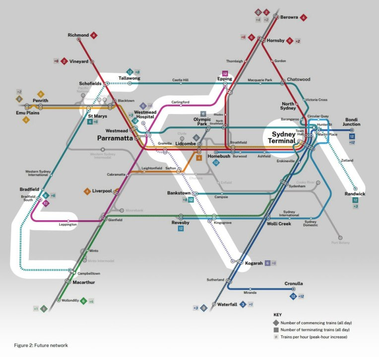
The figure below shows plans (slightly better than the Crayon doodlings we all do) published by the Sydney Morning Herald (apparently obtained from YouTube channel TrainGuy4 -- watch the video for in-depth detailing about the operational changes including ETCS and track reconfigurations) about mid-term future rail transit projects that would be prioritised if the leaked plans were to be adopted. The figure is from these articles in the SMH:

Overall this is mostly what is expected and has been discussed for a while in various official documents and plans. Starting at 12:00 and going counter-clockwise, I summarise the lines and their rationale (excluding discussion of costs):
First we see the Tallawong-Schofields extension. One wonders why this wasn’t done originally, it’s a very short segment and connects the Metro (M1) with the T1 Richmond service.
Second there is the Schofields - St. Mary’s extension of the under construction Western Sydney Airport (WSA) Metro. This extension will make that line more valuable, by opening up the line to two existing lines (Metro just mentioned above, and the existing T1 Sydney Trains service to Richmond). This also helps complete the loop around the City. Hopefully the design allows cross-platform transfers from either the M1 or Sydney Trains services.
Third there is the WSA Metro extension from Bradfield (noted as Bradfield South here, so that is baked in I guess) to Campbelltown (presumably through Oran Park and Narellan). Again, this has been on drawing boards for a while, Oran Park has already preserved right-of-way. So in terms of making the WSA Metro more valuable, this is additive, and connects to trips from the southwest.
Fourth there is the extension from Leppington to Bradfield South as a Heavy Rail (rather than Metro). Using Train technology avoids losing access for people currently on that line going east who would otherwise have to transfer were it a Metro. It takes advantage of existing infrastructure without spending money on Metro-conversion. It also provides direct train access to Bradfield South from Parramatta and Liverpool CBD, and a relatively short shuttle Metro to the Airport from there (I assume with free and easy cross-platform transfers). This opens up development opportunities at Rossmore, and perhaps other stops.
Fifth we have Kogarah (via Bexley, perhaps? with a station) to Kingsgrove to Bankstown to Sefton to Granville to Parramatta to Westmead Hospital. This is the major new line, rather than extension, of the plan. From a Sydney perspective, it provides circumferential movements from the South to the West. From a Parramatta-centric perspective it provides radial movements out of Parramatta to the Southeast. Presumably this will be ultimately be extended northward and southward.
Sixth we see the extension of the Sydney Metro West from Hunter Street in the CBD eastward to Randwick via Zetland. This has been long mooted, though Randwick recently got LRT service. Our unpublished work on this area (from a Student Honours Thesis) suggests a more eastward alignment produces more access per km, and that it should extend farther south to Matraville. This also begs the question of whether Zetland also gets the proposed LRT (Parramatta Road to Central to Green Square via Zetland).
Seventh: Parramatta to Epping via Carlingford. This corridor has long been identified as a need. Given the recent LRT construction in Parramatta, I am surprised this shows up as Trains or Metro rather than LRT. I assume it is planned to be tunnelled given the recent conversion of the right-of-way.
Eighth: Sydney Terminal. The video linked above goes into details about some reconfigurations.
What’s not here: (From my list of missing links, excluding above)
Bankstown to Liverpool.
Liverpool to WSA,
Westmead to WSA.
Randwick to Kogarah,
Parramatta to Bella Vista or Norwest, (a phase II or III of the Westmead to Kogarah Line)
Service to Sutherland Shire (Miranda) via Brighton-le-Sands and Sans Souci, (a phase III or II of the Westmead to Kogarah Line)
Chatswood (or Victoria Cross)-Manly and the Northern Beaches,
Strathfield to Hurstville.
What’s not shown: LRT, BRT.
Opposition: While it’s generally an upgrade of service, in some cases there are cuts. Capacity is finite and needs to be allocated. Cronulla’s (Liberal) leadership is upset at cuts to express trains. (which I presume are cut so that the South Coast can get more express services, and this has nothing to do with Cronulla voting Liberal and the government being Labor).
My take, based on decades of looking at maps with an accessibility lens: I think I agree that the lines included are preferred (more important in the short-term, likely have higher access produced to cost ratios) to the lines not included, though obviously that analysis should be done. Hopefully something or somebody will bring costs under control, so this can be done sooner rather than never.

